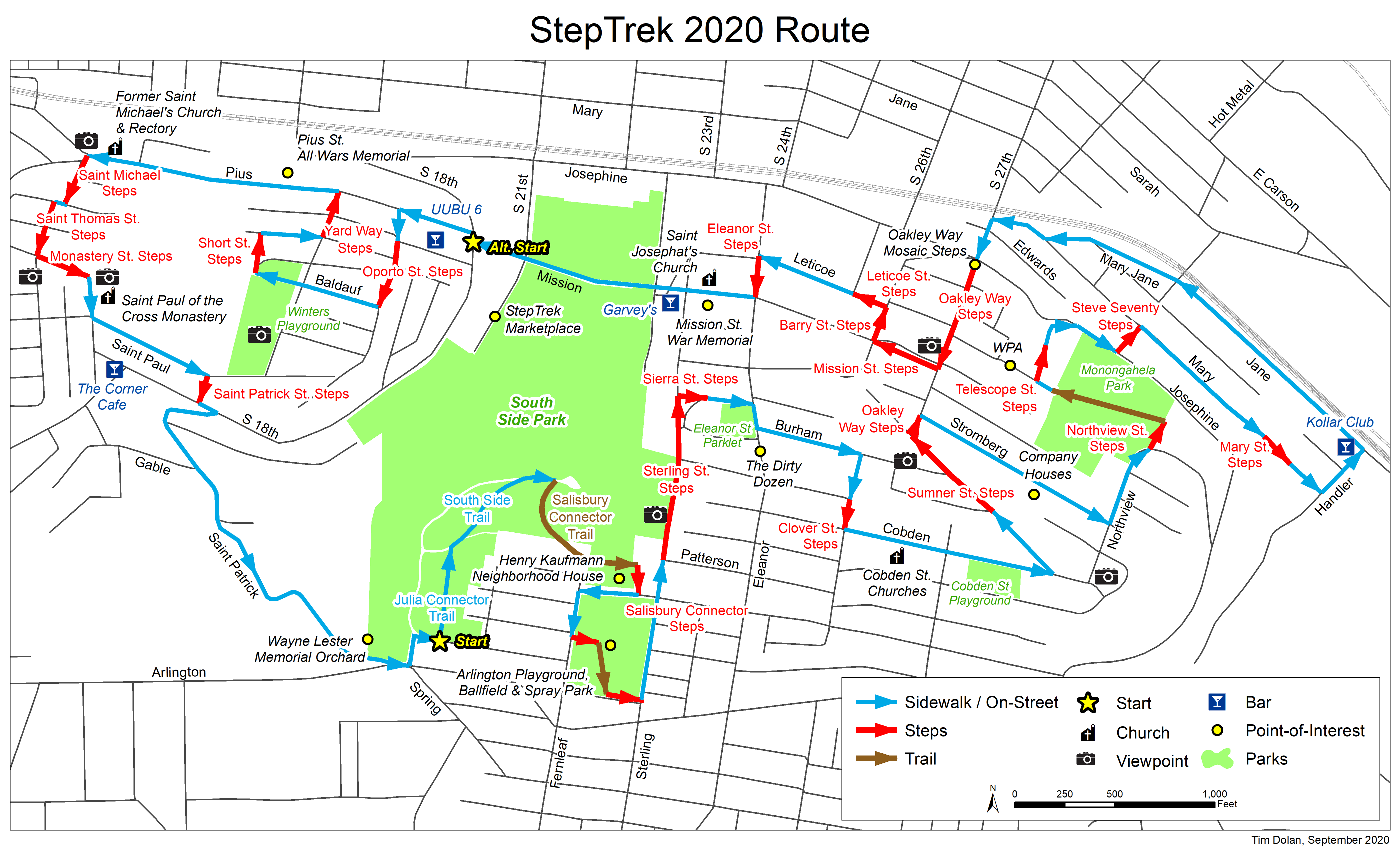
For 2020, there is one long StepTrek route that you may access from two different starting points. One begins at the top of the South Side Slopes at the public parking lot adjacent to intersection of Julia St. and Esop Way. The other begins on S. 21st Street, between the Mission St. Bridge and Josephine St. On-street parking is available on S. 21st Street.
From Julia St. – Start at #1 in the narrative.
From S. 21st St. and Josephine, start at direction #54 in the narrative.

From the parking lot, head north toward the Monongahela River. The Julia Connector Trailhead of South Side Park begins at the end of the parking lot.

Efforts continue to reclaim a 64 acre park that extends from the heights of the Slopes to Josephine St. below. In this wooded hillside are streams, ball fields and pathways. Volunteers have removed invasive knotweed and vines that choke the park and built its trails. With funding from The Brashear Association, SSSNA partnered with Pittsburgh Parks Conservancy, Landforce and the Student Conservation Association to create this neighborhood asset. Friends of South Side Park manage its ongoing work.

Continue along paved lane into the woods. At “T” intersection, make right and join South Side Trail. Continue along paved lane. No turns. Goats have been brought in to eat the invasive plants that have overcome the area. Improvements include the signage and newly planted trees. Just short of the paved oval is a trail post pointing to the Salisbury Connector Trail.

Turn right and take dirt path uphill to two sets of steps in the woods. About 50 feet in, turn left and walk up the first 8 steps, some made of wood, and another 18 stone steps. The trail will lead to the Henry Kaufmann Center. Pass along the rear of the Center and turn right at its edge. Climb the 11 steps along the side of the building to Salisbury St.

Make right and continue west to Fernleaf St.
The Brashear Association was founded in 1917 to honor the renowned, self-taught scientist John A. Brashear and celebrate his humanitarianism. The Henry Kaufmann Neighborhood House was constructed in 1965 as an outreach site. Brashear Association supports and enriches families in a community context to build more vital lives and neighborhoods in South Pittsburgh.

Make left. At the corner of Fernleaf and Eccles St., is the former Engine House #22 which was established in 1894. The new Engine House on Arlington Ave. replaced it. The building now serves as a residence. Continue up Fernleaf to the first set of stairs on the left, just opposite Eccles. Climb 23 steps to Arlington Playground, Ballfield & Spray Park.

For all its steepness, there are play and ball fields throughout the Slopes. This ballfield regularly hosts baseball and softball games under the lights which can be seen from the South Side Flats and Oakland. Take in views of downtown’s tallest buildings and Oakland’s medical complex. The Spray Park opened in 2018. Replacing a deteriorated city pool, the spray functions are many and varied. A children’s playground completes the park. Walk straight through and keep to left of yellow brick Parks Building. Descend 12 steps to Sterling St.
Make left and continue past Salisbury and Patterson St. to end of Sterling St. and steps on left.

Built in 1951, the steps connect to Mission St. below. Take in the view of the Mon River, downtown and the rooftops of South Side. When ready, descend 188 steps to grassy lot below 494 Sterling St. Across are Sierra St. Steps. A tall, weathered wood fence rises to their left.

Cross Sterling and climb 58 steps. Stay left along Sierra to Eleanor St. Above and to the right is Eleanor St. Parklet.
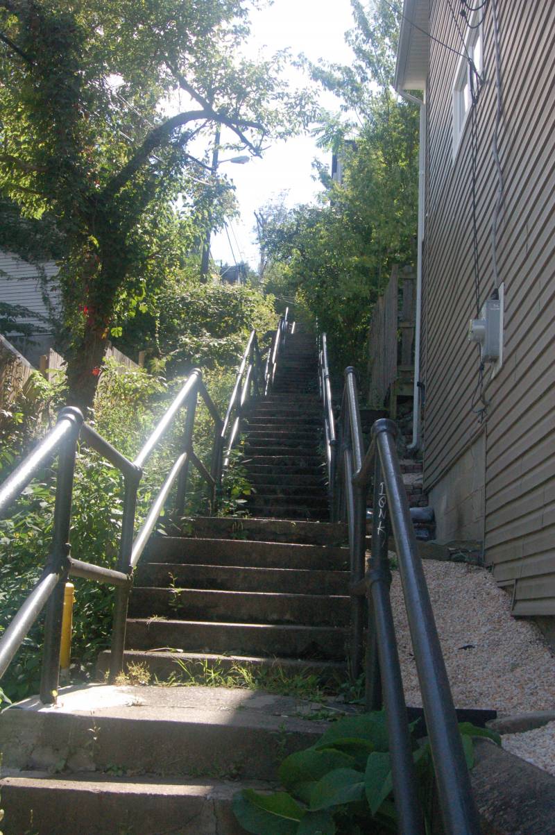
Cross to left side and make a right. Ascend one step and continue up half block to Burham St.

Every neighborhood needs a place where children can play. Tucked into the hillside, this parklet was rebuilt by Citiparks some years ago. The terrace of playground equipment and benches offers a stunning view of downtown and the Point, and is a favorite site to watch fireworks.

Each November, Pittsburgh hosts a 50-mile bike race that goes up 13 of its steepest hills. Eleanor St. is one of the Dirty Dozen.
Make left. Follow this street for one block to Clover St. Notice views to left of Uptown and Oakland across the Mon River.

Make a right and climb one short block to Wellington St. and Clover St. Steps.

Ascend 51 steps to Cobden St.
In this section of the Slopes are a couple of smaller churches. The Second Primative Methodist Church is at 2430 Cobden St. Cobden Street Baptist Church is on the right corner at 2500 Cobden St.

Make left. The course takes you along the spine of a knoll, with yards sloping down on either side. Look between homes on left for views of Oakland and a volunteer art project at 2733 Cobden St. Continue past Cologne St. to Sumner St.

Cross to right side and descend toward downtown Pittsburgh skyline. Just past Niles St., at 2735 Sumner, is a set of wood steps on the right. Drop down 4 steps to sidewalk. Rebuilt in 2012, the concrete walk continues below grade as it drops 27 steps along the right side of Sumner. Notice these homes sit below street level. Sets of wooden steps rise to the street. It’s a feature of streets scattered about the Slopes. Take in the view of downtown as you descend to Oakley Way. Here, the lots have widened into yards with gardens and fruit trees.

Make right. Keep right and descend to Stromberg St.

Make right and continue to Northview St.

Coal was mined in this area and transported by incline down the slope to the mills. To house the workers, the coal company built the eight houses on right, which begin at 2904 Stromberg. The first four have traditional tent or sloped roofs and the next four have pyramid roofs.

Turn left. Ahead is a commanding view of the Cathedral of Learning. Descend to where Northview bends to the right. On the left, just past the guardrail and before 3111 Northview, are Northview St. Steps.

Make a left and descend 113 steps through a nicely shaded area. The remains of a housing foundation rise near the bottom on the right. Where the steps come out of the woods is a park. Straight ahead is Josephine St. Make a left and walk through Monongahela Park. Do not descend to Josephine St.

Years ago this grassy area was a city reservoir. The basin was filled with earth in the 1950s. Cross the short clearing and descend 18 steps to the ball fields. Rugby and other pick up sports meet here regularly. Cross to the far left corner marked by a guardrail to exit the park onto Stella St.

Keep to the right and descend along Stella. Not 50 feet past the first house are Telescope St. Steps, located before 2739 Stella.

Stella St. is two levels here. On your left is an iron fence that divides the two sections. In 1935 the Work Projects Administration (WPA) terraced this part of the hillside and created the bi-level street topped with an iron fence. In 1998 Pittsburgh History & Landmarks Foundation designated the Stella-Shelley fence as a historically significant landmark.

Make a right and descend 56 steps to Telescope St. Continue down street as it bends to the right to Josephine St.
Carefully cross Josephine St. and make a right. Continue up the left side of Josephine to Steve Seventy Steps just past 2925 Josephine. Across and lining the uphill side of Josephine are the concrete walls of the former water reservoir that preceded Monongahela Park.

Make left. Descend 108 steps to Mary St. You are now in the area known as the Hollow. The brick, industrial building at 2933 Mary was recently converted to Print Shop Lofts. South Side Works lies in front of you.

The street is named after a Penna. State legislature who represented the area from 1979 to 1988. Since 1950, South 30th Street had been closed at the request of railroads serving the area's then-bustling steel mills. As a result, the only way into the largely Slovak community of the Hollow was along Mary St. Steve Seventy pushed to reopen the underpass to Sarah St., which came two years after his death in the 1990s and was renamed in his honor.

At the bottom of Steve Seventy St. steps, turn right on Mary St. Walk up Mary to where it ends at two sets of descending steps. Take the Mary St. steps on the right. They begin at 3200 Mary.
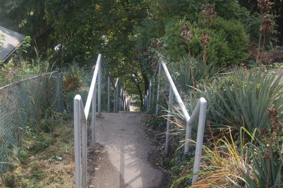
Descend 115 steps to lower Mary St. Continue to Handler St.

Turn left. Walk the four steps built into the sidewalk, left side, to Jane St.
Make left. Keep left and walk along sidewalk across from the stone wall and railroad tracks.

In the Hollow, at 3226 Jane St., resides the John Kollar Slovak Literary & Library Society. Founded in 1913 and named for 19th Century Slovak poet, John Kollar, its original purpose was to teach English to Slovak immigrants and to orient them to life in America. The Pittsburgh Region is home to more Slovaks than any other area in the United States. The club continues in full operation preserving the Slovak language & culture, and serving as a social club and live-music venue.
Keep left on Jane St. and continue walking past Jay Verno Studios (3030 Jane St.) to Steve Seventy St. South Side Works and Oakland are to your right. Cross Steve Seventy Way to Mary Jane St.
Keep left and walk Mary Jane past Harcum Way to Mary St.
Cross and keep left. Continue along Mary to S. 27th St.
Make left and walk up one block to Josephine St. and Oakley Way Steps & Mosaic Public Art Project

Be careful as you cross Josephine St. Climb the mosaic created on 77 of the first 98 steps, built in 1928, to McCord St. Notice the foundations of long gone houses on the left as you climb over the mosaic. Cross McCord St. Climb an additional 63 steps to Shelley St. Take a break. You’ve just climbed the equivalent of 12 floors.

The Oakley St. Steps mosaic was completed in 2016. The first of its kind in Pittsburgh, the installation was designed by artist Laura Jean McLaughlin, who led a group of 100 community volunteers in assembling the tiny mosaics on mesh. The finished panels cover 200 square feet and were mortared and grouted onto 77 risers. Led by SSSNA, the project was community-designed, funded and created.

Beginning at 2700 Stella are three of eight townhouses built in 2003 by the South Side Local Development Company in cooperation with the SSSNA. The new homes had to be shoe-horned into the hillside between existing homes. Continue walking Up Oakley Way.

Climb 22 steps to Shelly St. and then 98 steps to Mission St. Turn around and take in the view!

Cross Mission and climb five steps to high sidewalk on uphill side of street. Make right. Ahead lies the scenic St. Josaphat's Chapel and the spectacular view that takes in Mt. Washington, the Liberty, Fort Pitt and West End Bridges, the roofs of the South Side and the City beyond the Monongahela River. Stay left and descend the 80 steps to Barry St. These 4-foot wide steps were built in 1950.
Cross to the other side of Barry. Make a right and descend 16 steps to Leticoe St. Steps on left side.

Make left and descend 58 steps. Located at the eastern terminus of Leticoe St., these wooden steps have been reconstructed in stages beginning in the 1990's. At the bottom cross Kosciusko Way and continue up Leticoe St.
In the 2500 block, before the crest of the hill, look right to the houses tucked behind houses. Close quarters! Continue to Eleanor St. Steps.

Make left and ascend 100 steps to Mission Street. Eleanor is a paper street in this section. That is, it appears on a map as a street, even though it is passable only by its steps. Notice the house on the left whose only access is from the steps. Moving day here takes on new meaning.
Make a right and walk to Sterling Street and St. Josaphat Church.

Dedicated in 1916, the Roman Catholic Church was built to serve a Polish parish that was established in 1901. The building is Romanesque with a Byzantium influence evident in the arches, pillars and bell tower. The main altar held relics of St. Josaphat. In the rear, beneath the choir balcony, hung a picture of the Black Madonna. The consolidation of Catholic churches a few years ago had limited its usage to weddings and funerals. The church closed permanently after a section of ceiling collapsed about the casket of the last caretaker during his funeral mass. The church is being converted into multiple living units by a Slopes resident. Many Polish descendants continue to inhabit this section of the Slopes. The names of relations and former residents who served in World Wars I & II are visible on the memorial tucked into the hillside across Mission St. from the church.

Stay on Mission. After the first bridge is the Mission St. pumping station circa 1900, which delivers water into the neighborhood and surrounding area. A South Side Slopes Neighborhood Association (SSSNA) initiative in 2009 brightened this area at night by replacing existing street lighting with higher wattage lamps. To continue to West Side of 2020 StepTrek, cross the second bridge built in 1939 as a project of the Public Works Administration under FDR. That’s South Side Park below and rising up the hill to your left. Continue to S. 18th St.

If you parked along S. 21st Street and South Side Park, you can join 2020 StepTrek by climbing 102 steps under Mission St. Bridge to S. 18th St. Likewise, if you began 2020 StepTrek from S. 21st St., you can return to the start by descending the Mission St. Bridge Steps located beside the bus shelter on the left.
Cross S. 18th St. to Pius St. Keep left. Continue along Pius one block to Oporto St.
Make left and ascend left side of street to Gregory St. Climb the 26 Oporto St. Steps on the left to Roscoe St.

Cross Roscoe St. and climb the 125 steps to Baldauf St. To the left was the site of the Sankey brick yard that was active in the Slopes until the 1950s. Many a yard in the Slopes has a stash of Sankey bricks buried in the soil.

Ascend the final 10 wooden steps to Baldauf and make a right. Notice the houses on the right sit below grade, a feature seen in this steeply sloped neighborhood. The lower sidewalk is their only point of access. Continue to the end of the street, which becomes Short St.

At 1808 Short St. are a set of stairs. Descend the 105 steps to Magdalena St.
Make right and notice the views over the rooftops to downtown and the Hill District. Continue to Yard Way Steps.

Most of the steps on Yard Way date back to 1944 and number 317 in total. They are the longest set of stairs on this side of the slopes. Descend 38 steps to Gregory St. and the final 13 steps to Pius St. The last set of stairs were rebuilt in time for the first StepTrek in April 2000. In addition to providing a fascinating tour of this hillside neighborhood, the StepTrek encourages the city to make repairs to existing stairways for public safety.
Make left. Signage throughout the Slopes point out public stairs such as S. 18th St. Steps, located before 107 Pius St.

Just past 107 Pius St., overlooking South Side Flats, is a small, but well-kept All Wars Memorial. Tucked behind a gate and row of shrubs, the site honors veterans. State Elm Street funds permitted extensive improvements that included landscaping, fencing, sidewalks and new flagstone. The memorial, completed and rededicated on September 11, 2007, is maintained by Slopes residents.
Stay left and continue along Pius toward town. St. Michael Parish buildings once occupied this stretch of Pius St. The former convent at 66 Pius Street, on the left, is now a condominium complex.

At 44 Pius is the former St. Michael’s Madchen Schule and previous home of the Veronica’s Veil playhouse. The theater hosted a series of plays throughout the year but was most famous for its Passion play, Veronica’s Veil. Performed during Lent, it was said to be the longest running play in American community theater. These buildings were part of St. Michael’s Parish. The complex on the left includes the Burning Bush, which offers a retreat center for quiet meditation in overnight rooms.

The influence of the church was strong in the Slopes. St. Michael parish started in a house in 1848 where the church front now stands. Designed by Charles Bartberger of Stuttgart, Germany, the church was built between 1855 and 1860 on land donated by German immigrants. The surrounding land reminded them of the Rhine River valley. Though it has a gothic spire, the overall style is Rhineland Romanesque Rival similar to rural Bavarian churches. The church was closed through a consolidation of parishes and has been redeveloped into condominiums.
In 1849, a deadly cholera plague hit Pittsburgh. The parish could not find enough burial places for its deceased members. Parishioners prayed to St. Roch and vowed to keep a day holy if the plague would cease. It did. Another plague hit the South Side in 1853 but no members of St. Michael died. Cholera Day is observed each August in Prince of Peace Parish on the South Side, the successor to St. Michael Parish.

At corner of Brossville & Pius Streets, on the left, are the St. Michael St. Steps. They are part of the Church Route of the Slopes, which takes Trekkers past the significant churches built along the hillside. The permanent signs were installed in 2016. When ready, begin climbing these 149 steps.
At the top of St. Michael Steps is Hackstown St. Make right and cross to St. Thomas St. Steps, which are on left.

Ascend the 78 steps that lead to St. Joseph’s Way and St. Thomas St.
Continue up St. Thomas to Monastery St. Stay right to climb 5 steps. Look right at downtown and the rivers.

Cross street and make left to continue on Church Route. Ascend 15 steps on the right side. These steps and sidewalk were rebuilt a few years ago as part of a project to replace a larger set of steps that ran the length of Monastery. Ahead is St. Paul of the Cross Monastery.

Known as the barefoot missionaries, the Passionists vowed to live a life of prayer, poverty, penance and solitude. The first bishop of Pittsburgh invited the Italian order over in 1852. Designed by the architect Charles Bartberger, who also designed St. Michael Church, the church was completed in 1859 in the midst of an 11 acre compound chosen for its serenity, natural beauty and seclusion. The architectural style is Romanesque. The interior rose window is a copy of one in Reims, Germany. The newly renovated chapel is open daily from 7 a.m. to 5 p.m. Please step inside for a quiet observation. On exiting the chapel, take in the stunning view of downtown.
From the top of Monastery St., make a right and descend one block along left side of Monastery Ave.

Make left to follow Church Route. The orange brick building on the left is the St. Paul of the Cross Retreat Center, which is available for individual retreats by arrangement. SSSNA holds its meetings here. Continue down the street to the brick walls that are part of the monastery. The walls appear to be the original ones that shielded the enclave from the outside world. Parts of the garden and its Stations of the Cross can be seen from either end of the wall. Follow St. Paul to the end of the stone wall and cross to set of steps on the right.

Descend the 82 steps to S. 18th St.

Be careful as you cross S. 18th St. to St. Patrick. Descend 5 steps on the right. Be careful of metal plates placed on the street as part of PWSA update to water lines. You will walk up St. Patrick St. for approximately 1/3 mile to Arlington Ave. Keep left and continue past Saber Way on the left and Gable St. on the right. This winding, narrow road borders South Side Park as it cuts through the Slopes. The view toward the top is of Oakland and the University of Pittsburgh.

Just before the Fire Station Engine #22 and Arlington Ave. is the Wayne Lester Memorial Orchard. Mr. Lester, a Pittsburgh firefighter and active member of the Arlington community, was instrumental in planting the orchard adjacent to the fire station.
Make left. Just past the Fire Station is Julia St. Though unmarked, it begins at the corner of M. J. Stein Building. Climb 2 steps on left side.

Make left and walk one short block to Esop Way and Arlington Ballfield.

Make right and walk 100 feet to parking lot. Make left into parking lot to join Julia St. Connector Trailhead. If you started here, congrats on completing the 2020 StepTrek! If you joined at #40 and S. 21st St, pick up the rest of the narrative with direction #1.
For the printer-friendly narrative, click here.
Don’t forget to bring a fully charged mobile device to access the map and narrative. You’ll also want to bring water, snacks, a face mask, hand sanitizer and money for take-out food or drink.
Can’t get enough steps? Check out our Historic Route Series!


